Healing Balu River: Restoration of River Eco-System Through Revitalizing The Riparian Zone of Balu River, Dhaka
This research blog was principally based on observation and field survey. Books, journals, documents from websites etc. are the sources of secondary data. The study will explore the questions of restoring the unique natural dynamics of delta environment along with the diversified ecology of Balu River, as well as their integration with present and future urban development. In summation, this study aims to come up with a model which will combine a new city pattern with the rejuvenation of a river system, thus opening the doors to a totally new urban experience.
HYDROLOGYURBAN DESIGNLANDSCAPE URBANISMFEATURED
Shauni Priyam Sikder, Muhammad Golam Sami
12/18/202212 min read

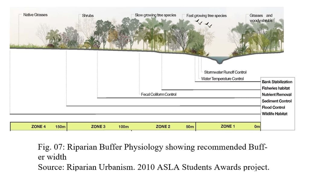
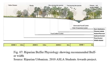
Source: Riparian Urbanism. 2010 ASLA Students Awards project.
1. Introduction:
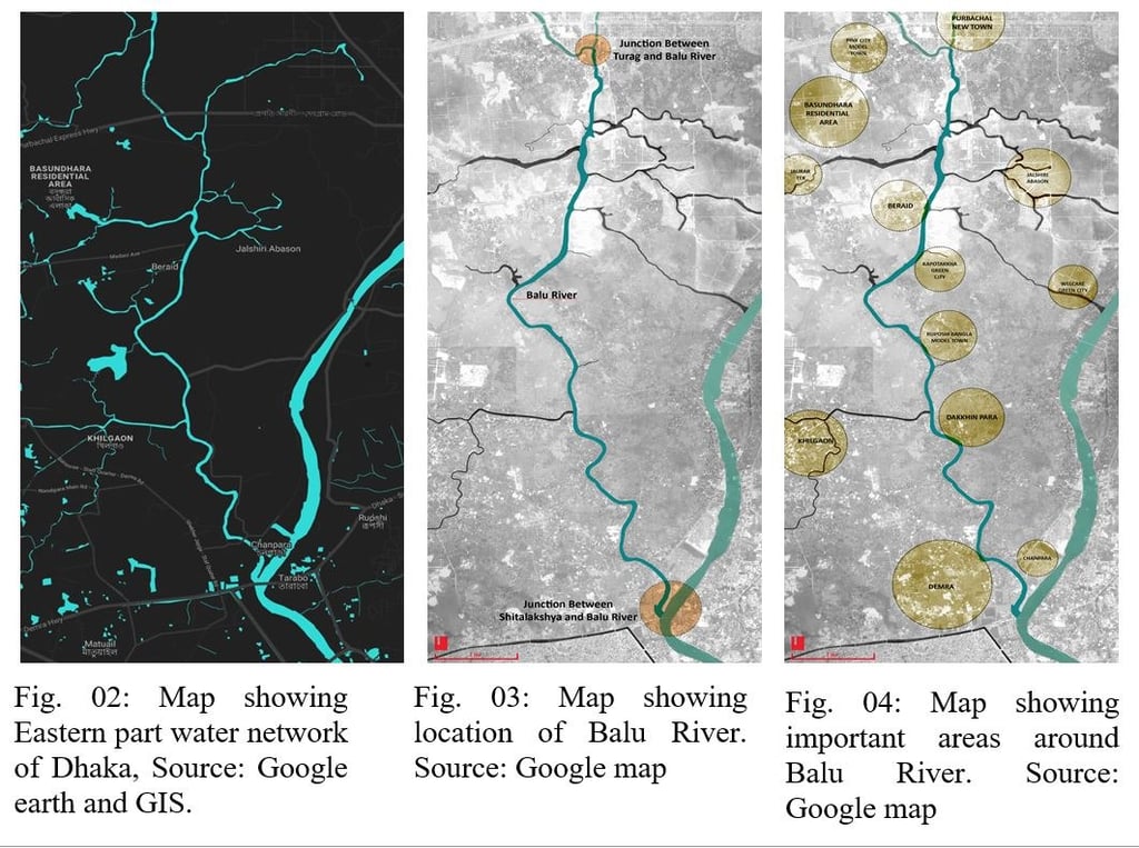
Throughout history, rivers have been omnipresent in people's lives. Almost all the most remarkable civilizations grew from river valleys. Bangladesh is a deltaic land. Its capital, Dhaka city, established by the Mughals on the bank of river Buriganga, is surrounded by six rivers (Balu and Sitalakhya on the eastern side, Turag and Buriganga on the western side, Tongi Khal to the north and Dhaleshwari to the south) like a garland. However, rapid urbanization and economic and industrial development have taken their toll on the river ecosystems. Balu River is one of the most significant rivers of eastern Dhaka, which carries excess water from Sitalakhya and Turag during seasonal floods and acts as a medium for local drainage. The river runs mainly through extensive swamps of Belai Beel, joining the Shitalakhya River near Demra ghat downstream. It also connects via the Tongi Canal with the Turag River, which flows along the northwestern side of Dhaka. Due to the massive discharge of urban waste waters, untreated effluents from the textile industry, agrochemicals, sewage, and solid waste, as well as oil spillage, storm runoff, and rapid encroachment, Balu is now on its deathbed in Rupganj and Beraid areas. The rivers are dying due to unplanned urbanization, encroachment, pollution, and improper demarcation. Such an approach to land development lacks an innovative understanding of planning cities, forming communities, dealing with an aquatic landscape, and creating public spaces. A 44 km long riverbank currently offers a challenging but excellent opportunity to develop a new urban edge by resuscitating the dying river with proper landscape intervention and planning strategies.
2. Literature Review:
· River Restoration:
River restoration is a rehabilitation process to reinstate natural processes by reviving biodiversity and reshaping rivers for a healthy ecosystem. All of this should be done while ensuring long-term recovery by addressing the root causes of damage. "In essence, river restoration is the process of recovery enhancement. Recovery enhancement enables river or stream ecosystems to stabilize (some sort of trophic balance) much faster than through the natural physical and biological process of habitat development and colonization. Recovery enhancement should establish a return to the ecosystem closely resembling unstressed surrounding areas." (Gore, 1985)
· River Restoration Process:
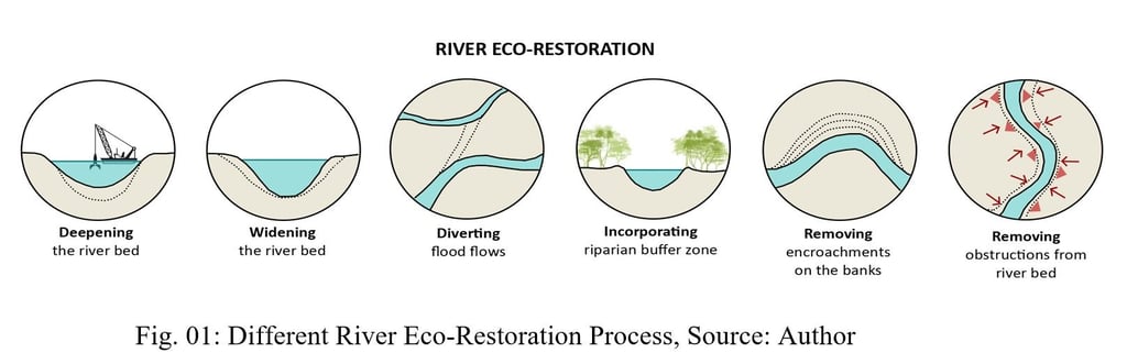
Due to rapid urbanization and urban sprawl in Bangladesh, rivers and their catchment areas and floodplains have been severely degraded. Such a situation requires healing the present polluted condition of urban rivers by restoring their ecological integrity. Some basic restoration methods are discussed below to understand the holistic approach of this idea.
A. Riparian buffer Management:
The riparian zone is a buffer between a river and anthropogenic activities within its catchment area. Riparian management, including revegetation of riparian zones, aims to restore the functions and processes inherent in riparian vegetation communities (Gregory et al.1991; Baxter et al.2005). Typical objectives include erosion control, biodiversity enhancement, water quality improvement, weed control, and improved aesthetics and recreation (for example, see Water and Rivers Commission, 1999) ([2], Chap. 11, Page- 173).
According to Welsch (1991), riparian buffers can intercept pollutants from the surface and ground before reaching a river or stream. Lade (1994) suggested that forested riparian and wetland buffers can help to protect stream water quality, provide wildlife habitat, preserve floodplains and wetlands, protect against erosion, and provide recreational values.
B. Instream Species Enhancement:
The instream species enhancement process can be used to directly manage aquatic species to achieve the expected upshot. This process may involve preserving, enhancing, and reinstating indigenous aquatic plants and animals.
· Restoration with Aquatic Plants: Riparian plantation is one of the most effective approaches for restoring both urban and non-urban rivers. Aquatic plants can purify water pollution to a certain degree. Plants having a strong absorption capacity for pollutants and good tolerance should be considered for river restoration. Bangladesh's standard pollution abatement aquatic plants are water hyacinth, common reed, duckweed, elodia, hydrilla, scripus, myriophyllum, azola and mersilea. [6]
· Restoration with Aquatic animals: Aquatic animals can be used to heal the river water from eutrophication, which is responsible for the production of algae, the depletion of fish species, the general declension of water quality, and adjusting the water structure. Using silver carp, common carp and other filter-feeding fish could effectively control eutrophication caused by phytoplankton (algae). (J. Wang, et al.2012, Page-1859)
C. Physical Remediation Proposals for River Restoration:
· Aeration: Water aeration is a process of increasing or maintaining the oxygen saturation in water. Aeration can restore and enhance micro-organisms' growth and vitality to improve the water quality. The aeration technology is a simple and effective method that began to be utilized in the early days of river restoration. (J.Wang et al.2012, page 1857).
· Water Diversion to Flush-out Pollutants: Water diversion is generally used to improve water quality and control river pollution. In this process, the clean water dilutes polluted water, resulting in discolorations and malodors vanishing quickly, thereby increasing the self-healing capacity of the water body. Anyhow, such a process is an expensive one for implementation.
· Sediment Dredging: As sand and silt wash downstream and gradually fill channels and harbors by sedimentation, these must be periodically removed. Dredging removes sediments and debris from the bottom of lakes, rivers, harbors, and other water bodies. Environmental dredging is often necessary because sediments around cities, their peripheries, and industrial areas are frequently contaminated with various pollutants. These pollutants are introduced to waterways from point sources such as sewer overflows, municipal and industrial discharges, and spills or may be introduced from nonpoint sources such as surface runoff and atmospheric deposition. [8]
D. Restoration via Wetland:
Creation of wetlands or utilization of existing wetlands may effectively intercept pollutant-rich surface runoff and increase infiltration. The approach is ecologically sound because it utilizes a well-functioning river system's inherent ability to filter pollutants and balance fluctuations in flow. This self-sustaining approach is more beneficial than hard-engineered solutions as it does not need periodic maintenance measures. (Palmer et al.2005)

3. Methodology:
This is a generalized study, and it is expected that the outcome of this study would be applicable in the context of Dhaka city. The study focuses on finding a suitable landscape solution to restore river edge and a possible buffering system to protect from future encroachment. The overall analysis has been conducted in several phases. A qualitative research method is used to address the research problems. The theoretical part is entirely based on a literature review, and the field research has been based on an empirical survey that collects primary data through visual observations, photographs, field surveys, sketches, and field notes. The paper represents the analysis of data contained in the site. Later, computer-aided drawings based on maps and field surveys were prepared. Finally, the analysis phase aimed to visualize a planning model to revive the declining situation of the Balu River.
4. Present Scenario of Balu River: Problem Statement
A. River Encroachment:
Illegal construction over a riverbank is known as river encroachment. Rapid river encroachment has been observed in peripheral river corridors of Dhaka City, and the extent of encroachment was:
● Turag (Abdullahpur>Gabtoli) 120.7943 acres
● Buriganga (Kamrangirchar>Bosila) 97.1697 acres
● Sitalakhya (Kanchpur>Narayanganj) 23.8315 acres
● Balu (Demra>Nandipara) 8.84 acres respectively, within areas of 5.75 miles, 7.41 miles, 3.56 miles, and 4.20 miles. (Md. A.I. Chowdhury, 2015, p- 1556).
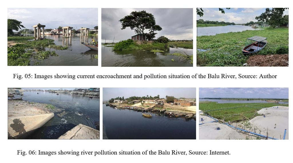
Though it has experienced the lowest extent of encroachment on the list, continuous land acquisition and pollution pose a significant threat to the existence of the Balu River. Invaders and realtors have already occupied both river banks from Rupganj in Narayanganj to Kaliganj in Gazipur. Extensive areas of river flood basin and river bank are being repurposed into urban residential projects. East West Property Development Ltd. has occupied a vast flood flow zone of the river for its Basundhara residential projects, and RAJUK, the authority for developing Dhaka, is filling up a portion of the Balu River in Rupganj near Sector-14 to develop its Purbachal New Town project. The River Saving Taskforce has recommended that Balu be kept at least 100 meters wide, whereas now it is just 30 meters wide. ([10], the Daily Star, February 23 2012). As the eastern part of Dhaka is developing rapidly, it is high time to rethink the master plan of these areas while considering the Balu River and its edge. If we remain indifferent towards the offenses of encroachers and local land grabbers, Balu River will inevitably face the miserable fate of Buriganga River.
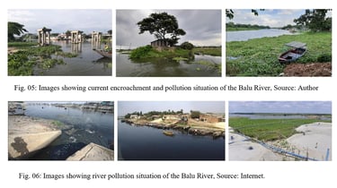
River pollution has become a common phenomenon in Dhaka due to rapid urbanization and industrialization, which stimulates the colossal discharge of night soil and industrial wastewater into water channels. Like Buriganga and Turag, Balu is under threat of extreme river pollution. According to a field survey, the major pollution point is Norai Khal. Norai khal is the wastewater source as the channel carries wastewater from several wastewater khals from the central part of Dhaka, including the Northeastern flood plain. The Balu River receives raw effluents from industrial zones near Tongi. Besides these, the river is slowly dwindling due to frequent encroachment. River banks are filled to construct new infrastructures, including buildings, brick kilns, markets, ghats, mosques, etc. The main reasons behind river pollution can be encapsulated as the following points;
· Frequent unplanned urbanization and industrialization, rapid land encroachment, and brickfield development.
· Improper use of river waters by its neighborhood and unhygienic latrine system of slum dwellers.
· Use of agrochemicals in agrarian lands.
· Untreated wastewater spillage from industries as the industries don't have any wastewater treatment plants.
· Oil spillage from boats and barges.
4. Healing Balu River: Revitalizing Riparian Zone
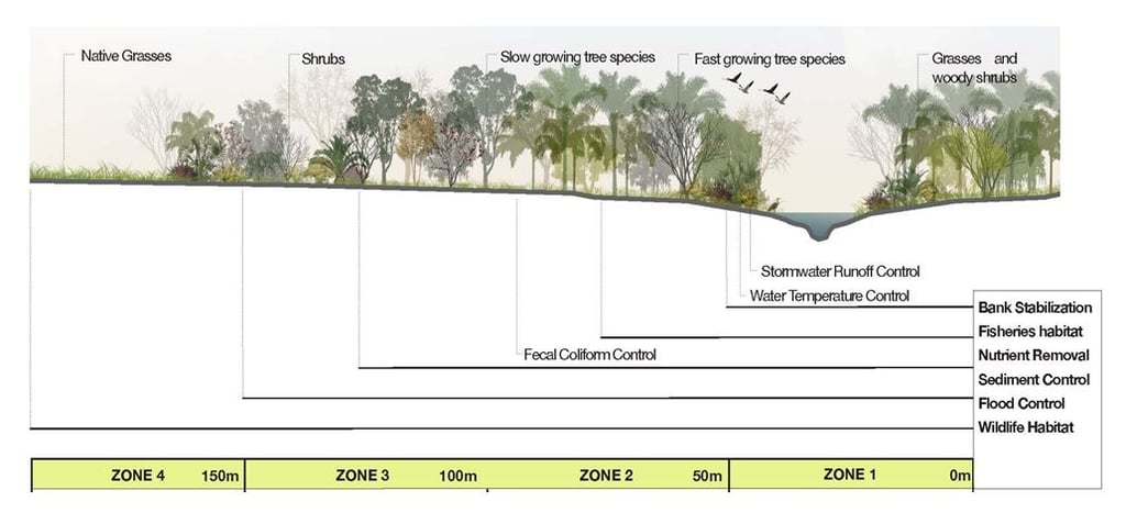
A typical morphology of an urban river is a straightened river channel with many hard edges, roads, paths, and buildings full of embankments and no riparian buffer areas. Even urban waterfront promenades are designed with maintained grass and selective trees. Such morphology doesn't promote ecological diversity within the city and acts as a downstream barrier to the ecology flow. The riparian zone is an interface between land and waterbody that allocates a 25-100m buffer from the river edge for ecological, environmental, economic, cultural, and transportation uses. A riparian buffer should be no less than 22.86 meters (75 feet) at its narrowest point. Such a pollution-free, vegetated zone is required to protect and purify the urban water system while providing contiguous wildlife habitat and corridors. Buffer depth fluctuates depending on adjacent land use patterns and urban growth. A riparian buffer is vital in ecology as a bio-filter, preventing soil erosion, and as a shelterbelt during hazardous events. Such a buffer zone must be considered while preparing a master plan for developing the eastern side of Dhaka.
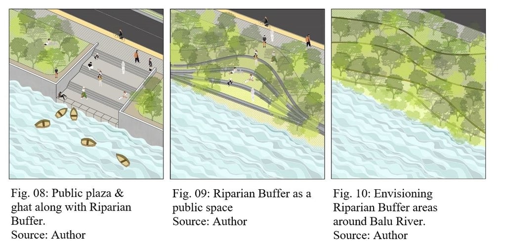
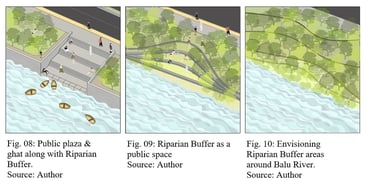
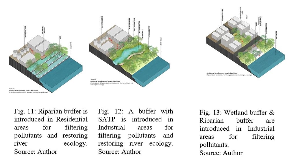
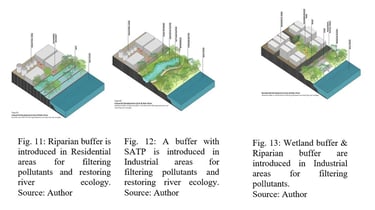
To revive the Balu River, a proper planning strategy must be planned to determine the characteristics of the urban water edge. As a future proposal, three urban riverfront edge designs can be introduced to ensure a proper buffer between the river and the neighborhood city areas. Planners and designers often find it difficult to spare enough land for public space due to the scarcity of vacant lands and high land values. These riparian buffer areas will introduce better urban opportunities to create public plazas, ghat, pocket parks and a new urban realm in such a situation.
The unplanned development of residential areas and expansion of industrial regions without a wastewater treatment plant is highly responsible for the dying situation of the Balu River. Currently, the river edge faces massive encroachment by Government and private housing projects. Besides residential development, the river water is polluted due to untreated industrial wastewater from Dhaka and Tongi. Generally, the potential pollution sources are industrial wastes from adjacent factories (paint, building materials), power stations, and municipal solid wastes that directly drain into the river.
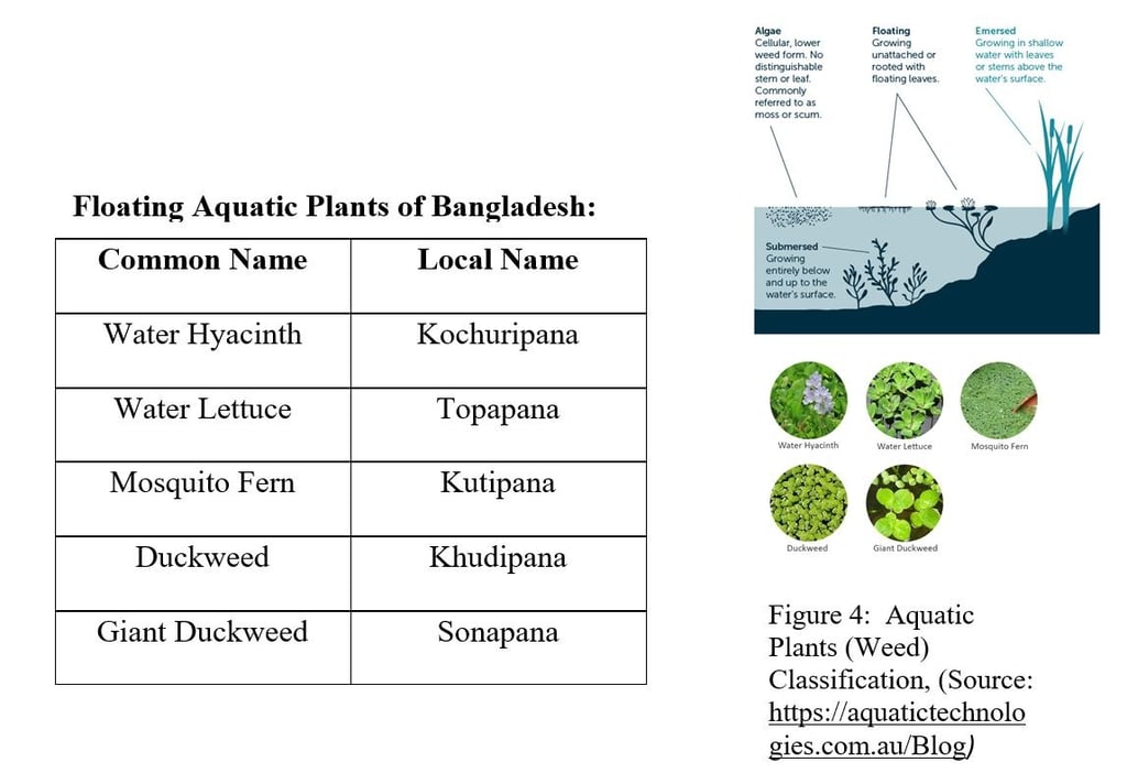
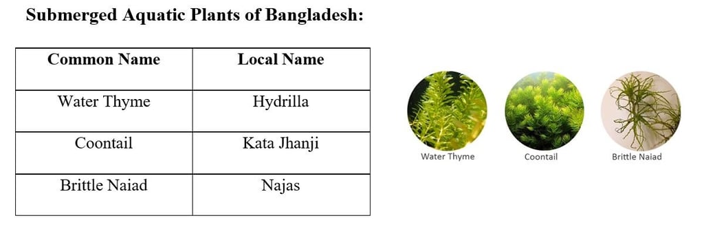
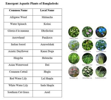
5. Improvement of Ecological Habitat:
Riparian plantations can purify water pollution to a certain degree as plants have a strong absorption capacity for pollutants and a good tolerance against toxic effluents. Generally, aquatic plants can be classified into three categories: Floating, Emergent, and submerged. Some aquatic plants of Bangladesh that may help rejuvenate the Balu River are being proposed below;


6. Policy to Mitigate the Situation:
People at the policy level seem indifferent to solving the deep-rooted problems associated with the Balu Rivers. But it is high time to rethink the issue at the policy level as most of the rivers are vanishing from our map.
· All the illegal encroachment should be removed, and the river edges should be free from encroachment.
· A proper landscape intervention for the buffer zone must be planned while preparing a master plan for the development of the eastern side of Dhaka.
· Land management laws must be introduced to recover the lands that have been invaded.
· To grow awareness among neighborhoods, awareness campaigns must be conducted.
· Wastewater treatment plants must be an integral part of all industrial zones.
· The government has been drafting a master plan to protect the Buriganga, Balu, and Shitalakshya that will also consider issues including wastewater management and the sewerage system.
7. Future Research Questions:
1. How can revitalizing riparian zones adjacent to the Balu River catalyze other sustainable development initiatives in eastern Dhaka?
2. Can this revitalization of the riparian zone contribute towards a livable city?
8. Delimitations:
The paper has a holistic approach. It does not aim to solve all the problems in the abstract but will look for possible rejuvenation strategies for the Balu River by salvaging water quality, conserving riparian buffer, and enhancing the riverine ecology. Our contribution is to visualize and inspire how the river zone could evolve after the physical cleansing of the Balu River. Additionally, due to time constraints, the effects of low flow conditions could not be observed directly, and secondary research was sought to illustrate the current scenario.
9. Conclusion:
A new city pattern can be imagined for Dhaka's eastern bank, where a sustainable landscape comprising wetlands and rivers will remain as they are with proper urban and architectural interventions. If we can revive the Balu River, concurrently fostering citizens' appreciation for water urbanism and landscape, it would be considered a turning point in Dhaka's journey toward a sustainable future. At present, it's not only a question of healing the river but also with it reviving the capital itself. If the river suffers from water contamination and a lack of robust conservation strategies, the city's ecological balance will eventually be destroyed, leaving Dhaka uninhabitable. An ecologically effective restoration will bring about lasting opportunities such as fish spawning and riparian plant germination, high nutrient regeneration and channel maintenance flows, and groundwater connectivity. The choice of interventions should be considered by understanding the severity and type of damage, land-use characteristics, the size and position of the river relative to the catchment area, and stakeholder requirements and goals. Lastly, even with complex limitations, finding an ecologically sound restoration strategy for healing the Balu River is almost impossible.
. References:
1. Gore, J. A. (Ed.). (1985). The Restoration of rivers and streams: theories and experience: Butterworth Publishers.
2. Book Reference: River restoration: a strategic approach to planning and management by Speed, Robert, Tickner, David, Naiman, Robert, Lei Gang, Sayers, Paul, Wei Yu, Li Yuanyuan, Huang Houjian, Cao Jianting, Yu Lili, Zhao Zhongnan.
3. Welsch, D.J. 1991. Riparian forest buffers: function and design for protection and enhancement of water resources. NA-PR-07-91. Randor, PA: U.S. Department of Agriculture, Forest Service, Northeastern Area State and Private Forestry.
4. Lade, K.P., 1994. Stream Buffer Characterization: Landsat TM and
SPOT Panchromatic Data Analysis of 100- and 300-Foot Riparian Buffers in the State of Maryland. IP&RSC Technical Paper, July 7. Salisbury, Maryland: Salisbury State University, 4p
4. Lade, K.P., 1994. Stream Buffer Characterization: Landsat TM andSPOT Panchromatic Data Analysis of 100- and 300-Foot RiparianBuffers in the State of Maryland. IP&RSC Technical Paper, July 7.Salisbury, Maryland: Salisbury State University.
5. J. Wang, X.D. Liu, J. Lu. 2012. Urban River Pollution Control and Remediation. The 18th Biennial Conference of International Society for Ecological Modelling. Procedia Environmental Sciences 13 (2012) 1856 – 1862.
6. Aquatic Plant. Banglapedia : National Encyclopedia of Bangladesh http://en.banglapedia.org/index.php?title=Aquatic_Plant
7. What is Dredging? By National Ocean service. National Oceanic and Atmospheric Administration. U.S Department of Commerce. https://oceanservice.noaa.gov/facts/dredging.html
8. M.A. PALMER E.S. BERNHARDT J. D. ALLAN P.S. LAKE G. ALEXANDER S. BROOKS J. CARR S. CLAYTON C. N. DAHM J. FOLLSTAD SHAH D. L. GALAT S. G. LOSS P. GOODWIN D.D. HART B. HASSETT R. JENKINSON G.M. KONDOLF R. LAVE J.L. MEYER T.K. O'DONNELL L. PAGANO E. SUDDUTH 2005. Standards for ecologically successful river restoration. Journal of Applied Ecology, 42 (2005), pp. 208-217.
9. Md. Ashraful Islam Chowdhury, Mohammed Amir Hossain Bhuyain and Mohammad Mahbub Kabir, 2015. Assessment of river encroachment and land- use patterns in Dhaka city and its peripheral rivers using GIS techniques. INTERNATIONAL JOURNAL OF GEOMATICS AND GEOSCIENCES Volume 6, No 2, 2015, (1556-1567)
Meet The AuthorS


Shauni Priyam Sikder
B. Arch, Bangladesh University of Engineering & Technology, Dhaka, Bangladesh
M. ADU, University of Notre Dame, Indiana, United States
Architect, Rugo/Raff Architects Ltd, Chicago, Illinois, USA


Muhammad Golam Sami
B. Arch, Khulna University of Engineering & Technology, Khulna, Bangladesh Architect | Futurist | Sustainable Design Expert
Operational Head, ADORA Studios, Bangladesh
Founder, samism.org
Lecturer, Department of Architecture
Northern University of Business & Technology
Related ARTICLES
Related PROJECTS
Regeneration of urban public realm: At the Commercial Waterfront of Barobazar, Khulna
This project design supports how the commercial waterfront of the Baro Bazar can be developed as an urban space, which will be used for human service and human welfare. At the same time, one of the objectives of this project is to retrofit the entire riverfront with its surroundings. One of the targets of this project is to restore the declining economic progress and the lost importance of the ghats. The entire project has been completed in the renovation and regeneration process.
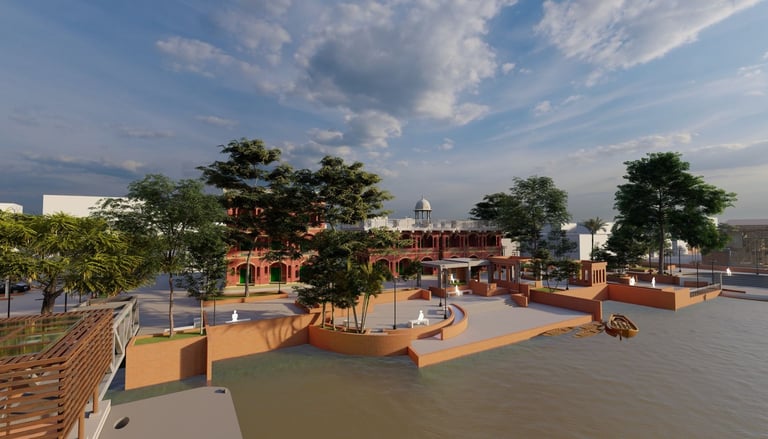
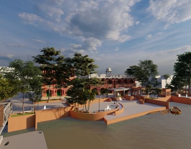
Image: Waterfront Regeneration at Barobazar Delta Ghat
Location: KUET, Khulna; Year: 2020