Historical Evolution of Barobazar, Khulna
Khulna is the 3rd largest city in Bangladesh. A city grew as a result of the river's authority. Khulna is known as an Industrial City since it is one of the country's most prominent industrial and commercial areas. The growth of Khulna from ancient Calnea is linked to the development of Barobazar.
URBAN DESIGNFEATURED
Muhammad Golam Sami , Mahmuda Yasmin Dola
2/13/20208 min read
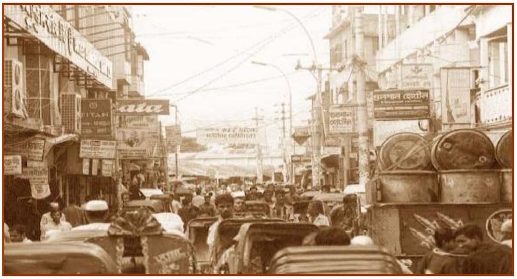
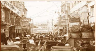
Image: Khulna Barobazar 2005
1.Introduction:
Khulna is the 3rd largest city in Bangladesh. A city grew as a result of the river's authority. Khulna is known as an Industrial City since it is one of the country's most prominent industrial and commercial areas. The growth of Khulna from ancient Calnea is linked to the development of Barobazar. The interweaving of two elements resulted in an urban fabric for modern Khulna. As a result, the city began as a market town. This report represents the economic, sociocultural, environmental, and built environmental aspects of the Barobazar and Kalibarighat zones, as well as the site strengths, weaknesses, conceived threats, and place-making opportunities in the context of creating a responsive urban design to improve the environmental and economy of the Barobazar and Kalibarighat zones.
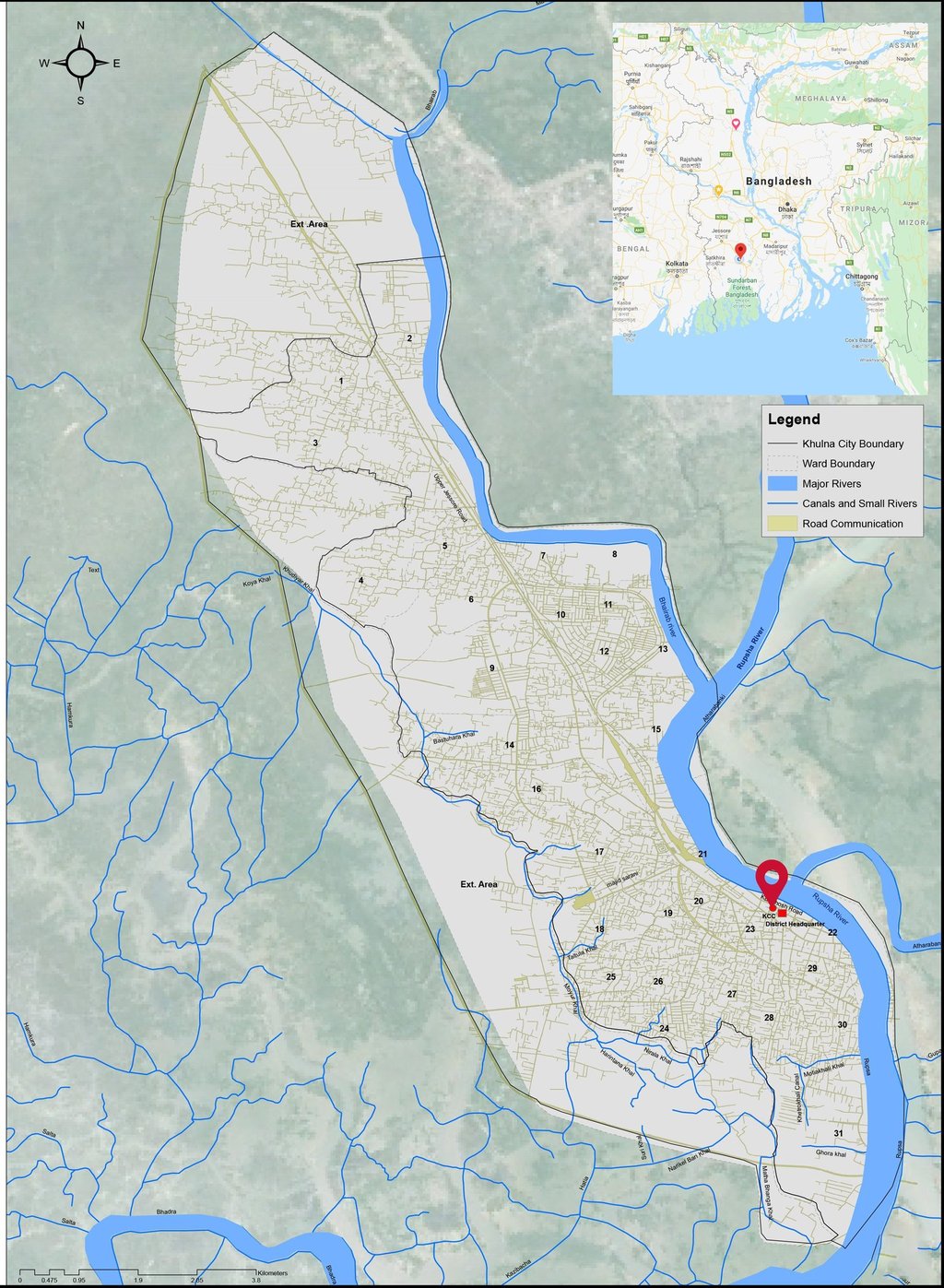

Figure 1: Map of Khulna City
Summers in the city are humid, while winters are pleasant. Khulna has an annual average temperature of 26.3 degrees Celsius (79.3 degrees Fahrenheit), with monthly average temperatures ranging from 12.4 degrees Celsius (54.3 degrees Fahrenheit) in January to 34.3 degrees Celsius (93.7 degrees Fahrenheit) in May. The yearly average rainfall is 1,809.4 mm (71.24 in), around 87 percent falling between May and October.
Khulna was part of the Vanga or Samatata kingdoms. During the 12th-century rule of Ballala Sena, it became a member of the Sena dynasty and was part of Bengal's Bagri division. The region's previous name was Jalalabad.
Shamsuddin Firoz Shah was the first Muslim ruler to arrive in the city during the 14th century; Muslim settlements expanded during the reign of Shamsuddin Ilyas Shah, and many mosques and shrines were built. During the 15th century, a Muslim saint named Khan Jahan Ali obtained a jagir (fiefdom) with a considerable chunk of the Khulna Division from the ruler of Gaua. Ali maintained complete sovereign privileges till his death in 1459.
After Ali's death, the city was returned to the Sultanate of Bengal. When Daud Khan Karrani fought the Mughals in the 16th century, Vikramaditya (one of Karrani's chief ministers) gained a grant in southern Bengal, including Khulna. Vikramaditya founded an independent kingdom with Iswaripur as its capital (currently in Jessore District). He was followed by his son, Pratapaditya, who dominated the Baro-Bhuyans and ruled over southern Bengal. In 1611, Man Singh I, a Hindu general of Mughal emperor Akbar, defeated Vikramaditya.
Khulna was ruled by autonomous Bengali nawabs (rulers) until 1793, when the British East India Company abolished Nizamat (local rule) and assumed city control. In 1842, the city was included in Jessore District, and 1882, it was renamed Khulna District (the Khulna and Bagerhat subdivisions of Jessore District, the Satkhira subdivision of 24 Parganas District, and the Sundarbans). 1884, Khulna had a Pouroshava (municipal council), which later became a municipal corporation in 1984. During this time, a haat called Charlie's Haat was constructed by a British company, later renamed Barobazar.
Before 19 August 1947, Khulna district was part of undivided Bengal. Khulna was first declared part of India in 1947, and the Indian flag was flown on 15 August. Syed Mohammad Abdul Halim, an official of the then Bengal civil service, wrote the memorandum and sent it to the boundary commission to include Khulna in Pakistan; the boundary commission declared Khulna under the East Bengal province.
Figure 3: Expansion and transformation timeline of Khulna
2.Site context, geolocation & evolution:
Khulna is the third-largest city in Bangladesh, after Dhaka and Chittagong. It is located in the southwestern portion of the country, on the Rupsha and Bhairab Rivers, and has an area of 59.57 square kilometers (23.00 square miles); the district has an area of 4,394.46 square kilometers (1,696.71 sq mi). Khulna is located to the south of Jessore and Narail, to the east of Satkhira, to the west of Bagerhat, and the north of the Bay of Bengal. It is a component of the Ganges Delta, the largest river delta in the world. The Sundarbans, the world's most extensive mangrove forest, is located in the delta's southern reaches. The district's northern boundary is Khulna, while the district's western boundary is the Mayur River.

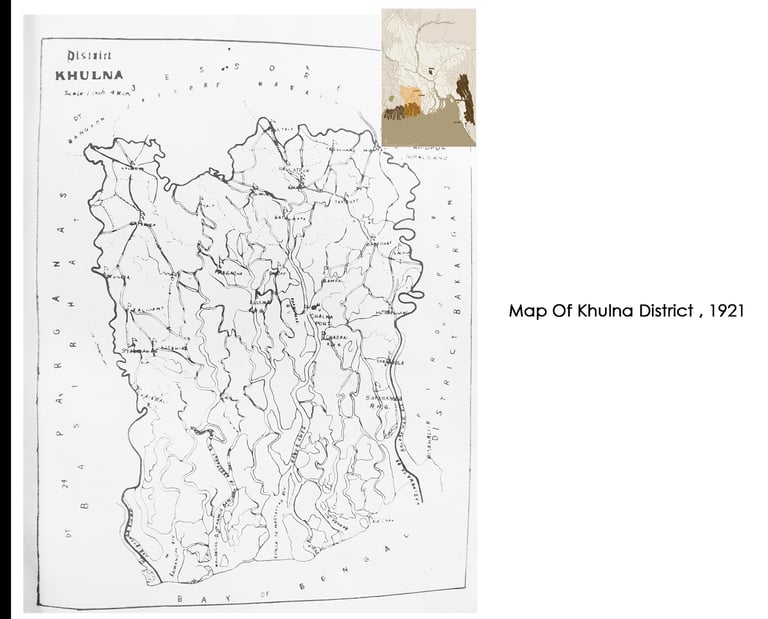
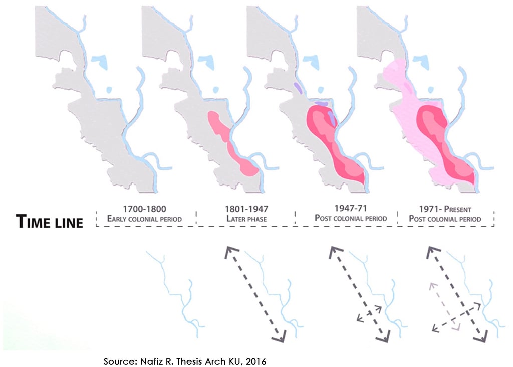
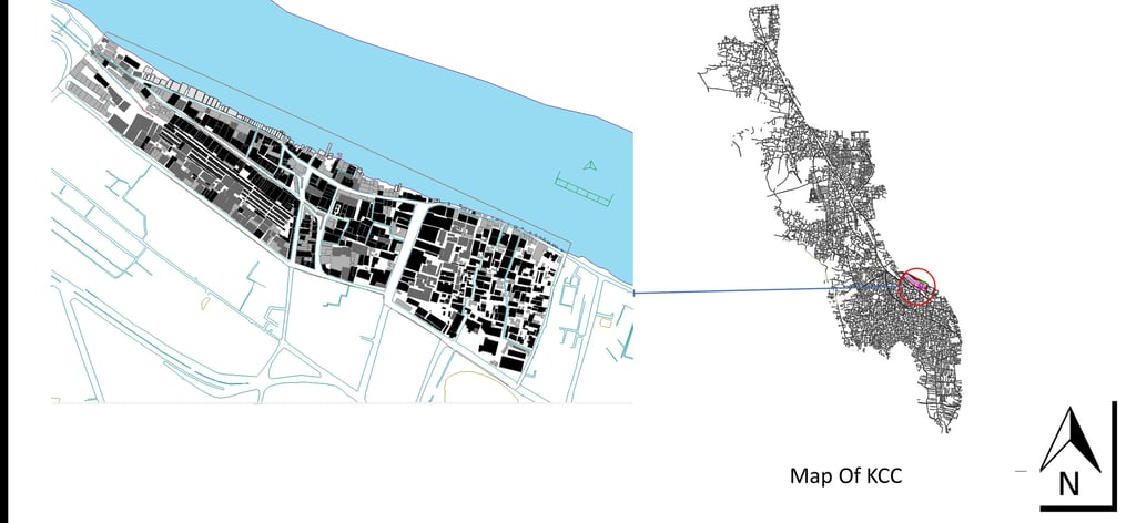

Figure 2: Khulna district map, 1921
3.Barobazar - Kalibarighat Zone Geolocation & Context
Barobazar, Khulna, is located in the heart of Khulna City, the region's major business center. It grew as river-based trade and commerce influenced Khulna's city economy. That is why the city sprang up along the river bank known locally as "Barobazar," or the large market area. The city's rapid shift shaped Barobazar as a mixed-use zone rather than a purely commercial or business zone. For the past decade, Barobazar has encountered compact, unplanned growth along the riverside to meet the need for increasing urbanization. The Kalibari Ghat zone afterward evolved based on the Barobazar financial influx.
Barobazar and Kalibari Ghat are located at the coordinates 22.82 and 89.56. The Borobazar is located 5.7 meters above sea level. The entire land area is approximately 38.1236 acres. The estimated population is 11,972 individuals, with an additional 7,965 workers who do not live here.
Figure 4: Location of Khulna Barobazar and Kalibari Ghat zone in Khulna

Figure 5: Evolution of Khulna Barobazar and Kalibari Ghat zone
4.1700-1835 : Early Colonial Period
The original Bhairab riverbank was a grassy plain. From 1707 to 1772, the Zamindars of Jessore owned the entire area. After the British East India Corporation abolished Nizamat (local rules), the company acquired control of the area and created an Indigo Factory in 1790 (really the last part of the 18th century or possibly 1800AD). Mr. Charles (Charlie), an associate of Mr. Edward (administrative Chief of British East India Company, Vanga Zone) in Calnea Zone, went there as an Indigo Ax in 1835 and created a village haat there at the riverside Old Bhairab. Charlie's Haat/ Chollet Shaheber Haat / Charlie Ganj is the name of the haat.
Acknowledgements: Syeda Nurun Nahar Zahra, Sarder Shafiqul Islam, Nahin Uddin Mollick
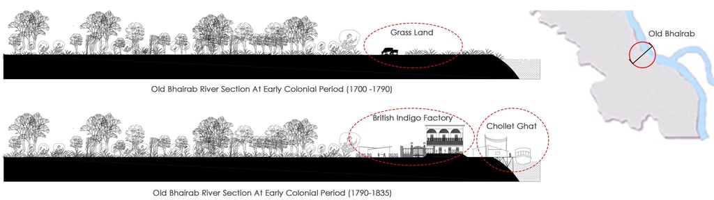
Figure 6: Early Colonial period sections
5.1835- 1947: Colonial Period
The Factory was closed after the Indigo Revolt (1860), but the haat remained. Calnea was well-known as a seaport by this time, and the haat flourished. Because of the British East India Company employees, the haat was dubbed "Shaheber Haat." The hamlet haat became the central commercial core for the new town once Khulna (Calnea) was elevated to the status of Mahakuma & Zilla Sadar.
In 1880, Steamer Service (local people called it rocket) started, and the haat became important for trade & commerce and turned into a Bazaar ( Marketplace). They established a Cloth market near Delta Ghat in 1890. The goods came from Dhaka, Tangail & even from India. Steamer with goods came at Delta Ghat. 1884, rail was also established, and a rapid trade movement grew. Jain businessmen from Calcutta and other part of India came here for business purposes. They established different wholesale shops, godowns & other business concerns here. Some of them (Jains) permanently started living here and created a mixed-use commercial zone there. They established several temples for their religious culture, such as the Satyanarayan Estate Temple (1911). A kachari was also established near Kachari Ghat by Rai Kiran Chandra, Rai Bahadur (1910), Zamindar of Jessore; belongs to the Narail family privileged to have twenty retainers; b. 1869. The British established some old brick road connections in the Bazar. After establishing Lower Jessore Road, which was connected to Calcutta, the place became a center of commerce. From the haat culture, a Brothel had developed near the steamer ghat ( Delta Ghat), one of this subcontinent's most lavish brothels. But during the Pakistan period, the brothel was demolished.
6.1947 -1971 : Post-Colonial Peirod ( Pakistan Period)
During the Pakistan period, an EPR colony (tin shed buildings) was erected on railway property on the west side of the Bazar, between the rail line and the Lower Jessore Road. Residential hotels and official residential zones (Kalibari Ghat) were constructed on the east side of bazaar Sonapatti to meet the needs of the increasing metropolis.
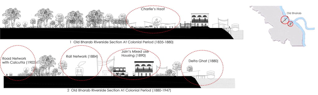
Figure 7: Colonial and Pakistan period sections
7.1971-Present: Post-Colonial Period (Independent Bangladesh)
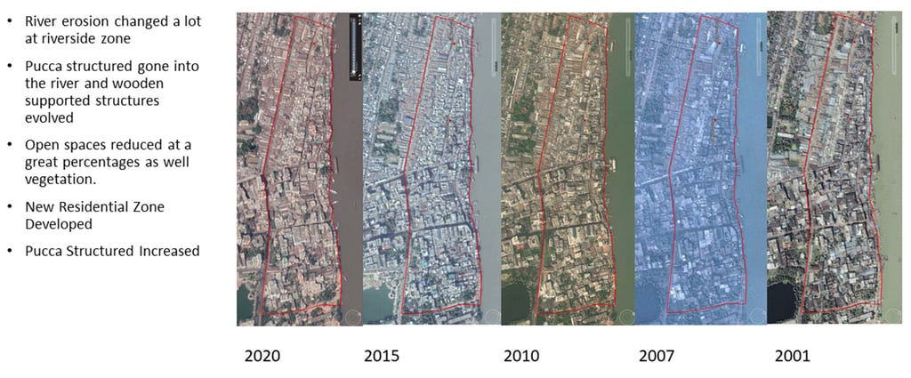
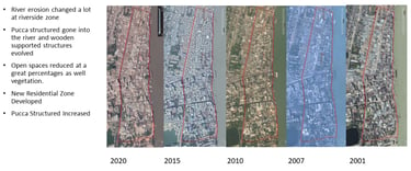
The EPR colony was dismantled, and after the Station Road was constructed in 1985, a godown and wholesale zone emerged on railway property. There was also the development of A hawkers’ market. Following the abandonment of the rail line, the entire area of railway property was seized, and the wholesale market and hawkers' market expanded. Due to river rules and erosion, many shops and infrastructures have been washed away. As a result, wooden-structured stores sprouted up there. Currently, the bazaar is critical to the financial flow of South West Bangladesh.
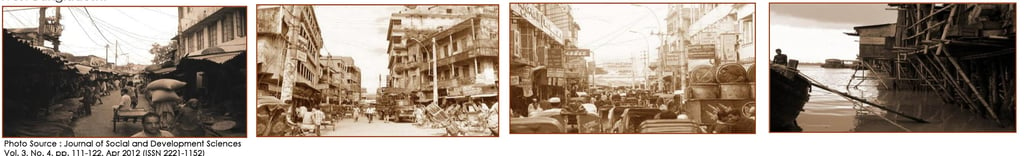
Figure 8: Khulna Barobazar at the last decade
8.Evolution Of River Network
The Barobazar was built on the bank of the old Bhairab. The Rupsa was not present at the time. Bhairab walked down the opposite side of the judge's market, towards Alaipur, on the east side of Sen's bazaar. A smaller canal than the curve was located downstream. Rupalal Shah, a Narail salt merchant, cut the canal to the south for easier access and connected it to the Bhairab and Mayu rivers. It was near the conclusion of the first half of the twentieth century. That canal is now known as the Rupsa River. Rupalal Shah was the inspiration for the name. As a result, the majority of historic infrastructures have been bulldozed into rupsa, with only a few remaining today.
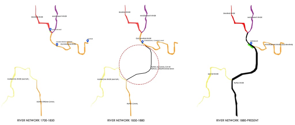
Figure 9: Creation of Rupsa river
9.Morphological Map Analysis (Last 20 Years)
Meet The AuthorS


Muhammad Golam Sami
B. Arch, Khulna University of Engineering & Technology, Khulna, Bangladesh Architect | Futurist | Sustainable Design Expert
Operational Head, ADORA Studios, Bangladesh
Founder, samism.org
Lecturer, Department of Architecture
Northern University of Business & Technology


Mahmuda Yasmin Dola
B. Arch, Khulna University of Engineering & Technology, Khulna, Bangladesh Architect | Analytical Practitioner
Head of Construction, ADORA Studios, Bangladesh
CMO & Head of Construction, SS Construction & Power Solution, Bangladesh
Related ARTICLES
Related PROJECTS
Regeneration of urban public realm: At the Commercial Waterfront of Barobazar, Khulna
This project design supports how the commercial waterfront of the Baro Bazar can be developed as an urban space, which will be used for human service and human welfare. At the same time, one of the objectives of this project is to retrofit the entire riverfront with its surroundings. One of the targets of this project is to restore the declining economic progress and the lost importance of the ghats. The entire project has been completed in the renovation and regeneration process.
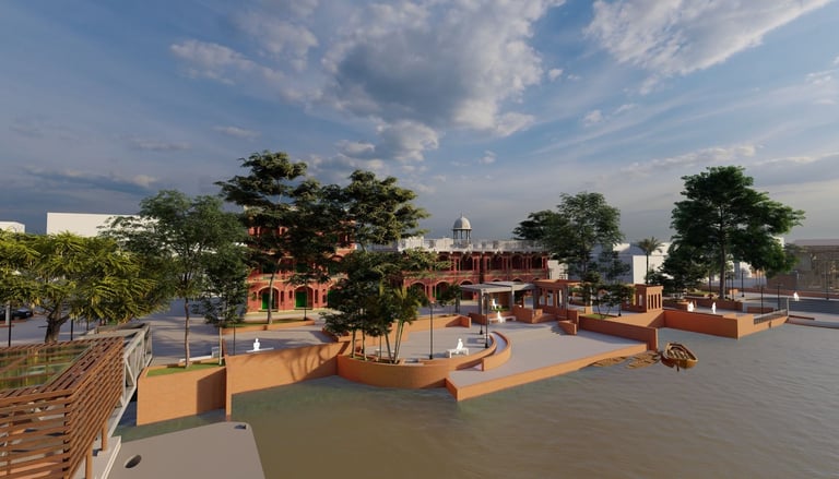
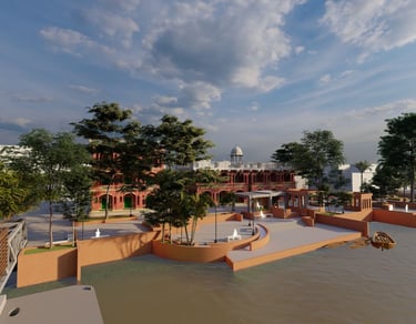
Image: Waterfront Regeneration at Barobazar Delta Ghat
Location: KUET, Khulna; Year: 2020