Strategies and Site Based Analysis for The Renovation of Azimpur Govt. Housing
In this blog, I have discussed the methodologies and site-based analysis of Azimpur Govt in detail. Housing for the renovation process.
SUSTAINABLE LIVING
Muhammad Golam Sami
1/5/202315 min read
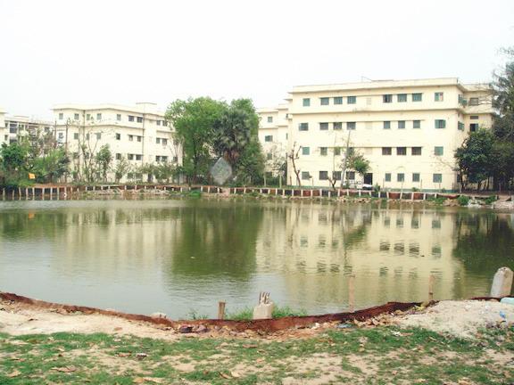
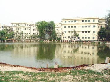
Image: Old Azimpur Govt. Housing
Methodology: The methodology outlines the steps to be taken for the information and data gathering, analysis, and conformance with research. One of the major difficulties, the trend of apartment housing by private developers, has been picked as the current research topic after extensive and critical observation of the many challenges in Dhaka. The following research steps were used to achieve the study’s goals, and a flow chart is provided in the methodological framework section.
a) Introduction: The majority of housing-related operations are carried out on behalf of the government in the public sector by the Ministry of Housing and Public Works and other ministries and directorates within it, including the Department of Architecture, Public Works Department (PWD), Housing & Settlement Directorate (HSD), City Development Authority known as Rajdhani Unnayn Kartripakkhya (RajUK), Urban Development Directorate (UDD), etc. In the previous 40 years, the public sector has most likely contributed less than 10%, directly or indirectly, to total urban housing activities. The official private sector has lately emerged, but it is only active in one or two major cities, despite the small number of sites and services projects, public rehabilitation, core housing, flats for sale, and slum upgrading.
The demands of government employees have been the main focus of public housing. High-ranking officials used to live in bungalows erected during the British era, while workers lived in barracks. Following the partition of India in 1947, there was a huge challenge with regard to housing government employees who had relocated from India. The Pakistan Public Works Department constructed Motijheel Colony in Dhaka and Agrabad Colony in Chittagong to serve the needs of the general public and provide public housing for Central Government personnel. For its employees in Dhaka, the Provincial Government established Azimpur Colony.
b) Data Collection: The data collection procedure has been constructed in different sections. First, we must design the sample for FDG (Focus Group Discussion Survey). Determining the main and sub-target groups will help identify the actual scenarios on the site.
i) Main Target Group-
Ø People Who lived in Old and New Azimpur
Ø Age Group= 40+,50+,60+
Ø People Who Lived in New Azimpur
Ø Age Group= 20+,30+,40+
ii) Other Target Group-
People Who Lived In Motijheel and Agargoan Govt. Housing
Sampling Procedure: Purposing Sampling (A collection of non-probability sampling strategies known as “purposive sampling” include choosing units for your sample based on their possession of specific qualities. In other words, purposive sampling selects units “on purpose.")
Ø Sector: Housing, PWD, Department of Architecture, Government Housing Ordinance, Climatical Solution, Environment, Health & Wellbeing, Community Neighboring
Ø Desired Outcome: New Directional Govt. Housing
Next is to determine data collection procedure. The two types of data collection will be executed in this part. One is Primary data (data produced by the researcher, such as surveys, interviews, and experiments specifically created for comprehending and resolving the current study challenge). The user survey (FGD, KII) and site survey would perform to fulfill the desired outcome from primary data.
Methods of User Survey
Ø FGD (Focus Group Discussion): A experienced moderator conducts FGDs, which are preset semi-structured interviews. The moderator’s objective is to stimulate the most conversation and viewpoints possible in the allotted time. In order to encourage comments and spark conversation among the participants, the moderator asks open-ended questions.
Ø Questionnaire( Open-ended): Typically, these open-ended inquiries serve to establish the mood for the focus group. They will determine your group’s degree of interest and product knowledge and establish the tone for the focus group conversation.
Ø KII (Key Informant Interview): Key informant interviews are in-depth qualitative discussions with individuals who are knowledgeable about the local community. Key informant interviews serve the objective of gathering data from a wide range of persons who have firsthand knowledge of the community, such as community leaders, professionals, or citizens.
Ø Interview & Discussion: Qualitative approaches frequently concentrate in-depth on a small number of examples yet offer comprehensive justification (read more Qualitative Methods). Two examples of practical qualitative approaches are focused qualitative interviews and focus group talks. Additionally, observations will be illustrated using instances.
Also, the collectible data from the field survey-
Ø Temporal Experience: We are able to discern motion, change, and the order and length of occurrences. We are always conscious of how our thoughts are moving. For a very long time, philosophers have attempted to offer a comprehensive and cohesive explanation of these temporal features of experience.
Ø Morphological Experience: an organized investigation into an occurrence guided by lessons from past case studies but less rigorous than a formal hazard analysis depicted in experience.
Ø Communal Vibrancy: A successful community cherishes and promotes its artistic side. We are rewarded with novel narrative strategies, chances for self-expression, and a universal language as we work to promote a diverse range of artistic and cultural institutions.
Ø Structural Experience: Structural experience leads to formal hazard analysis and expression of dwelling in the means of built form.
Ø Spatial Experience: A purposely constructed environment that is intended to cater to the user’s wants and interests as well as those of their community gives rise to a spatial experience. It is essential to take into account a constructed space’s function in relation to its surroundings since created spaces have an incremental impact on their surrounding communities.
Methods of Site Survey:
Ø Spatial Mapping Observation method: The capacity to produce a 3D map of the environment is known as spatial mapping (also known as 3D reconstruction). It enables a technology to comprehend the actual environment and communicate with it. The avoidance of collisions, the planning of mobility, and the realistic mixing of the real and virtual worlds all benefit from spatial mapping. Building information modelling is a good technique for spatial mapping observation analysis.
Ø Geo Location Imaging: Geolocation refers to the assignment, alteration, and use of metadata that identify the location where photos or videos were shot. These metadata can originate from your camera, a separate GPS receiver, or other sources of geographic data, like maps.
Ø Use of electrical devices-camera, phones, Drones
Collecting Information
Ø Mapping (Geo Locating Referencing): Georeferencing is the process of connecting a digital map or aerial photo’s internal coordinate system to a geographic coordinate system on the ground.
Ø Land Use Survey (Local): Using land use surveys, it is possible to determine how a town or city uses its land. You must determine one of the following six categories each building on a street belongs in: residential, retail, commercial/professional, industrial, or recreational.
Ø Geo-Location Imaging: Finding the place where a picture or video was taken is known as geo-localization. Large-scale geo-localization systems that use methods akin to image matching and are designed for ground-level imaging have recently gained a lot of interest.
Ø Hydrological Survey: The management of the sustainable use of ground water resources, groundwater flow, groundwater chemistry, and the movement of particles, solutes, and energy are all topics of study.
Ø Climatic Survey: A climate survey is a method for gathering and evaluating employee thoughts, sentiments, perceptions, and expectations about a range of aspects important to sustaining the climate of the business, such as development opportunities, management, working relationships, surroundings, etc.
Ø Demographic Survey
o Occupancy
o Population Density
o Gender Scope – Age Group
Ø Infrastructural Survey: Protective Security Advisors (PSAs) work with facility owners and operators to identify and record the facility’s overall security and resilience using the Infrastructure Survey Tool (IST), a voluntary web-based evaluation.
Ø Structural Survey: A structural survey, also known as a building survey, is a thorough examination of a building to assess its condition.
Ø Safety and Security: Analysing safety and security measurement through accessibility.
Ø Community Space and Neighborhood
Ø Environmental Survey:
o Flora & Fauna: Animal & ground vegetation analysis
o Pollution Level: Measuring pollution with the help of different indicators
Ø Spatial Survey:
o Open Space Ratio: Measuring the available space and analyzing the ratio with ground coverage.
Ø Accessibility:
o Traffic & Vehicular Access: Analyzing how many vehicles pass daily and at night.
o Pedestrian Access: Analyzing the doorway created with the patrons or customers of that specific function in mind is referred to as pedestrian access.
Secondary Data Collection Methodology:
GIS Survey: Geo-spatial maps regarding the site
GIS Data Collection Method-
Ø LGED of Bangladesh
Information Collected:
Ø Public Private Ownership: Ownership regarding the government or other state-run organizations owning, overseeing, and managing public sector organizations and individuals, groups, or commercial entities own, control, and manage private sector organizations.
Ø Area of Distribution: Total area distributed on ach sector.
Ø Accessibility Information: Road, traffic, gateways.
Ø Infrastructural Occupancy: Typology of infrastructure.
Digital Elevation Model
Prepared By-
Ø DCC & RAJUK
Information Collected:
Ø Surrounding Elevation: Own made Digital Elevation Model
Building Information Modelling Study
Prepared By:
Ø Myself
Data Collected From
Ø Field Survey
Ø PWD
Usable For:
Ø Climatic Analysis
Ø Spatial Analysis
Ø Distribution Analysis
Ø Material Analysis
Ø Infrastructural Analysis
Ø Sustainable Approach
Literature Review
a) Documents:
Ø Government Housing Ordinance
Ø Survey Analytics Of PWD
Ø Documents: MHPW
Ø Thesis M. URP – BUET’06
Ø Thesis M. Arch – BUET ’10
b) Usable For:
Will help for the preparation of Design Analytical Framework
Remote Sensing Study: By measuring the reflected and emitted radiation of an area from a distance, remote sensing is the process of identifying and keeping track of the physical features of a location (typically from satellite or aircraft). Remotely sensed photos are captured by specialized cameras and are used by scientists to “feel” the Earth.
c) Method:
Ø Satellite Imaging
Ø Google Image
Mapping & Modelling Review
a) Method
Ø Survey & Satellite Experience
Ø Amalgamated Data: Collaboration of data from different resources.
b) Prepared Maps:
Ø Morphological Growth : The examination of how the built environment is created and how it evolves in relation to the spatial analysis of urban forms, land use, building, public spaces, and road layouts.
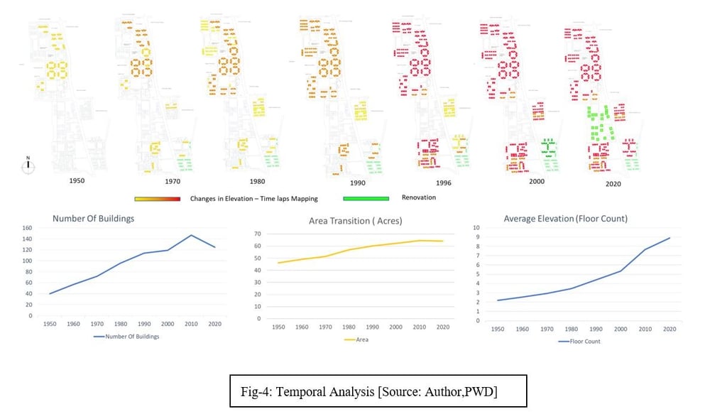
Ø Temporal Analysis
c) Usable For:
Ø Reasoning & Further Reasoning of the Project Thesis
Data Analysis:
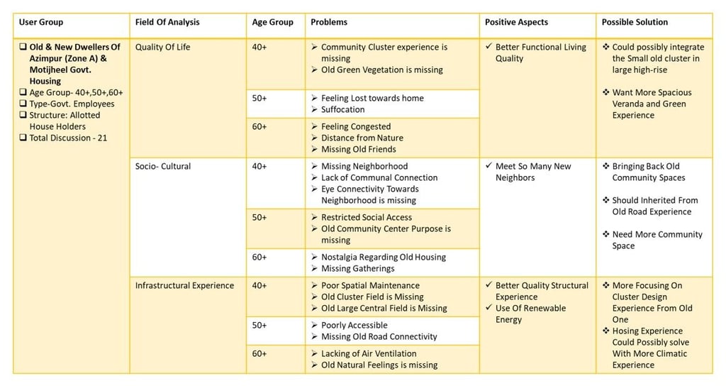
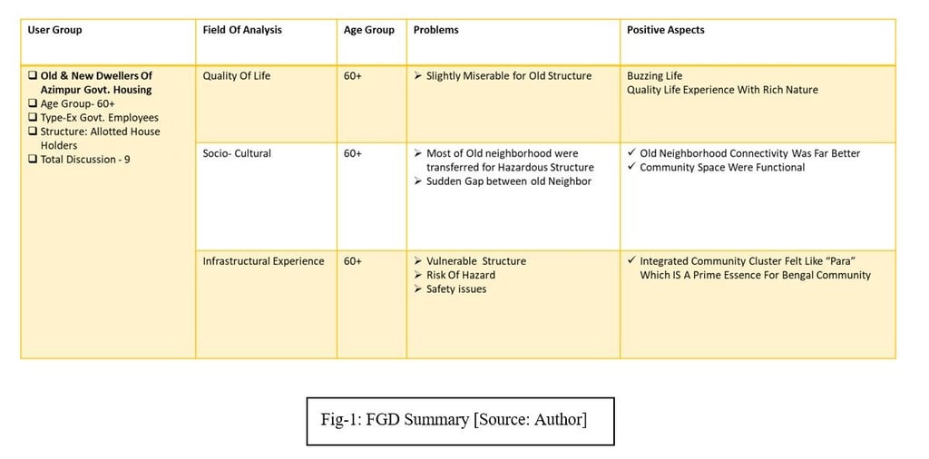
Summary Of FGD Analysis: The FGD has been categorized into three prime sections quality of life, sociocultral and infrastructural experience. The group discussion focused on different sub-categories under these three categories and concluded upon positive aspects and possible solutions.
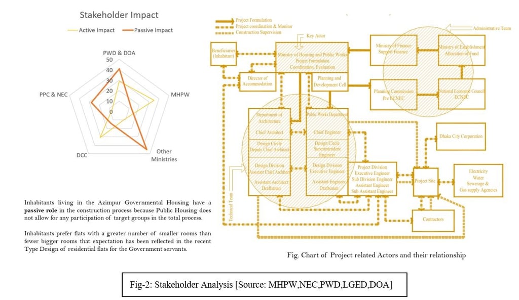
Summary of KII (Key Informant Interview) and Stakeholder impact analysis: The key-informant interview depicts the actual scenarios of the development procedure, stakeholder impact and future directions. The analysis and stakeholder flow are stated below:
Site Details:
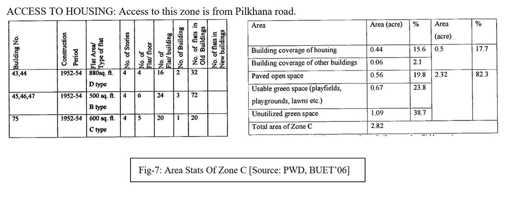
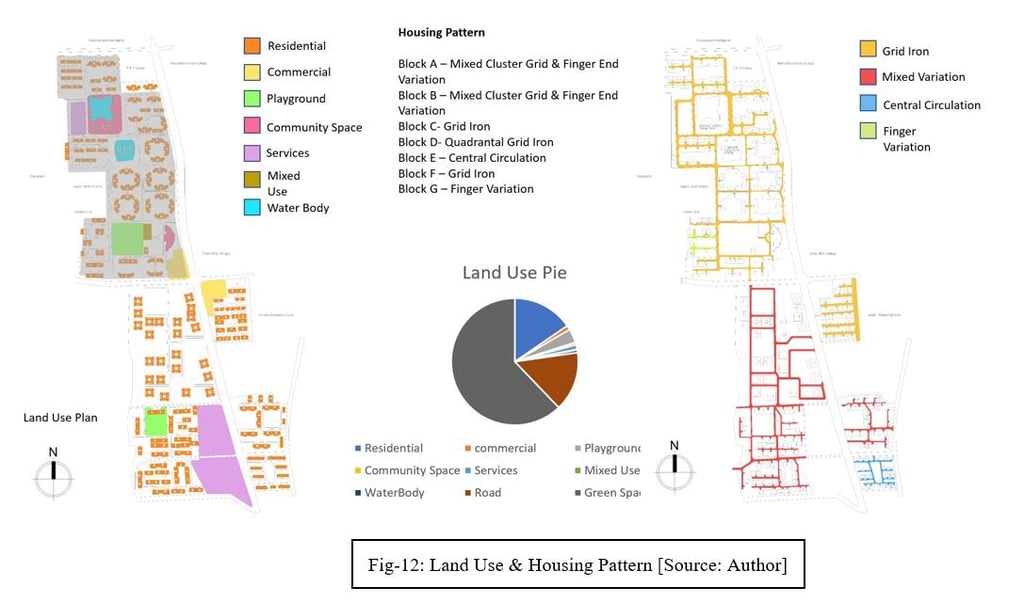
Zone C: This plot is 2.82 acres in size and is situated to the northeast of Pilkhana Road. The four-story, six-story building blocks that were built in this region between 1952 and 1954 will be torn down. There are 124 units in all in this neighborhood. There is just one child care facility in this area.
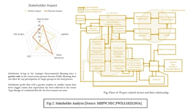
Demographic Analysis & Area Density Projection: The newly developing Azimpur Govt. will have a massive change in area density projection. The analysis of projection data is illustrated below:
Temporal Analysis (Past, Present, Future): The temporal analysis of Azimpur Govt. Housing (for last 70 years) is illustrated below:
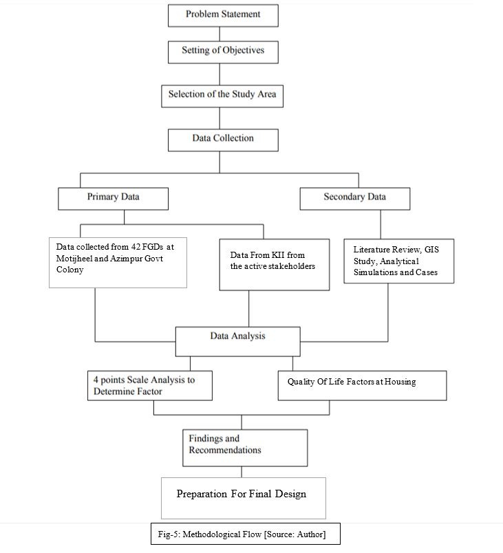
Methodological Framework: The methodological framework states the whole design decision process from the beginning of the problem statement to the Findings and recommendation. The methodological flow chart for this project is displayed below:
Site Analysis: The site analysis is a part of primary data collection from the site survey and a collaboration with the secondary geospatial data. The site analysis will depict the condition of the site, including zoning, surroundings, previous development, accessibility, traffic conditions, vegetation, hydrology and climatic aspects.
Site Introduction: After partition in 1947, the arrival of large numbers of the Muslim population from India led to an increase of Dhaka's population by 103%. Dhaka was a Zila town with an urban area of 6-7 sq. miles only. It didn’t have high land to build infrastructure quickly to cope as the capital city of the Eastern wing of Pakistan. The Govt. took up construction of colony-type residential blocks in 1948-49 at the open spaces of Azimpur and Motijheel. Initially, 42 numbers of 3-storey apartment blocks each with 12 flats were taken up in Azimpur and completed in 1951.
Most of the top bureaucrats, teachers, lawyers, doctors and engineers immediately after the ’47 partition stayed in this colony.
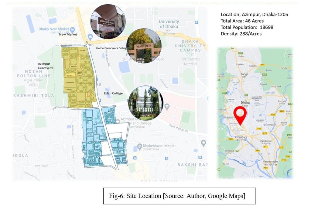
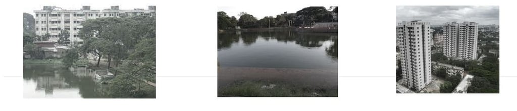
Azimpur Governmental Housing is the first government multi-storey walk-up residential flats housing complex for government employees inside the confines of Dhaka (figure 1). The former provincial government created this residential flat project in the 1950s, consisting of three-story building units appropriate for six families, based on a typology consisting of two flats for two families and a staircase in between that had been grouped in a cluster with an open space in the centre. On 46 acres of land, 240 residential flats (E and F type flats) with sizes ranging from 1531 square feet to 1741 square feet were planned for government employees with middle- and higher-middle-class incomes.
These structures were increased to four stories in the 1970s due to the steadily rising demand for government housing. This low-density government housing, which was constructed on (46.00+1.00+2.82) acres of land bordered by Govt New Market, Peelkhana Road, and Azimpur Road and includes a community center, playground, girls’ school, and three ponds, is a successful example of housing for higher-middle-income and middle-income government officers.
On 23.64 acres of land extending eastward from Peelkhana Road up to Sir Salimullah Muslim Orphanage, D-type and C-type apartments have been constructed for middle-class and lower-middle-class government employees. These apartments range in size from 650 square feet to 850 square feet. 800 square-foot C-type apartments were constructed simultaneously.
A government housing complex called Palashi Barracks was constructed on 5.39 acres of land, and C-type flats were constructed on 4.08 acres of land next to the Palashi Maternity Center to the east of Azimpur Road. This government housing program was built on 85.00 acres of land and is bordered by a large commercial district, a cinema, Eden Girls’ College, a home economics college, an engineering university, a cemetery, a health center, etc. It is also just a short walk from a graveyard.
Site Location: The site is located at Azimpur, Dhaka. Which is in the South-East zone of Dhaka. Govt. has decided to develop 27 -20 storied buildings in zones D & C. This project aims to revise the renovation process. The site is surrounded by New Market, Eden College, Home Economics College, Agrani Girls High School, Ladies Club and Azimpur Graveyard.
Past Records:
Ø AREA: 2.82 acres (pWD office record)
Ø Housing Building Coverage: 19040 sq. ft.= 0.44 acre
Ø Building coverage of
Ø Childcare center: 0.06 acre
Ø Total building coverage = 0.5 acres
Ø Area of Child -care center: 0.06 acre
Ø No. of Gates: 1
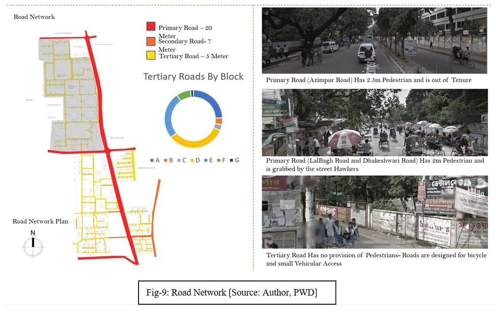
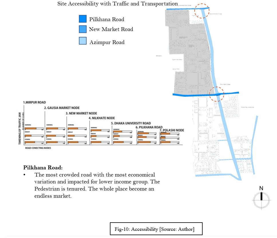
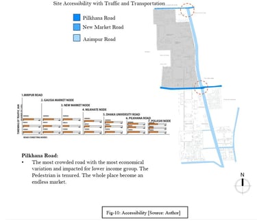
Circulation: From Pilkhana Road, there is just one main highway. The gridiron layout was used to create the road network. Two minor collection roads run along the north and south sides of the buildings. In this region, all of the dwelling buildings have been arranged in a straight line with 80-foot gaps between them. There is no designated pedestrian path.
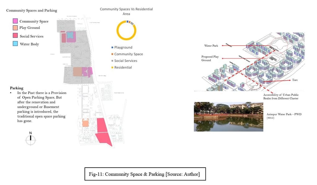
Open Spaces: This zone lacks any designated open space, play areas, play fields, or playgrounds except the space in between buildings. Include one daycare establishment for children located nearby. Community resources.
Garages & Parkings: There are no parking garages available. On the building’s front road, cars are parked.
Lots of plantation/vegetation surrounds the buildings and in their front yards.
Street lighting is in good condition and is carefully maintained.
SECURITY: A guard is always in charge of the entry point.
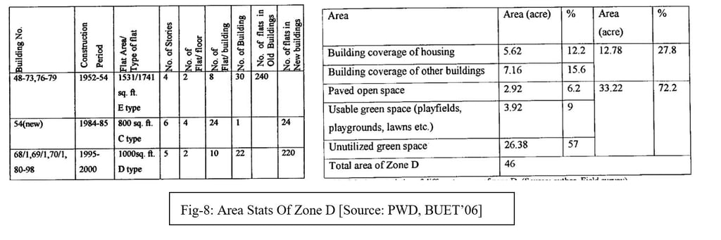
Zone D:
New Market Road, Pilkhana Road, and Azimpur Road border this 46-acre area. This neighborhood has four 30-story buildings built between 1952 and 1954, six 1-story buildings constructed between 1984 and 1985, and five 22-story buildings built between 1994 and 1995. There are 484 apartments in the old (240) and new (244) buildings. Out of the 46 acres of land in area D, 11 acres are set aside for community amenities such as playgrounds, Mazars, pump houses, and mosques. In comparison, 35 acres are explicitly used for housing.
Access to Housing: This zone is from Azimpur Road and Pilkhana Road.
Ø AREA: 46.00 acres (PWD office record)
Ø Housing Building Coverage: 242720 sq. ft.= 5.62 acre
Ø Building coverage of school, mosque, club, community center and other buildings: 0.91 acre
Ø Total building coverage = 12.78 acres
Ø Area of pond 1: 1.29 acres
Ø Area of pond 2: 1.00 acres
Ø Area of the playground: 1.45 acres
Ø Area of playfield: 0.17 acre
Ø Area of community center: 1.43 acres
Ø Area of Agrani school: 3.16 acres
Ø Area of Ladies club: 0.88 acre
Ø Area of Mosque: 1.25 acre
Ø Area of Mazar: 0.13 acre
Ø Area of WASA pump house: 0.31 acre
Ø No of Gates: 4
Circulation Three main thoroughfares are accessible from Azimpur Road, and one main thoroughfare is accessible from Pilkhana Road. The gridiron layout was used to create the road network. no designated pedestrian path. In this zone, courtyard-style design, maintaining open space in the center where older housing blocks have been installed, and linear building planning in the vicinity of recently installed structures can all be seen.
Open Spaces: This area includes a playground, a playfield, a sizable open green space in front of the mosque, and smaller green spaces that are utilized for outdoor enjoyment. This residence contains two ponds. There are no kid-friendly play areas with equipment. Users on the ground level respect the privacy of the open areas. Two buildings had been placed in each cluster of four buildings with the incorrect orientation facing east and west, creating an open area amid each cluster. Due to the hot, humid environment in the area, these structures are hot in the summer and chilly in the winter, making living there miserable.
Repetition of a basic flat structure in a plan that represents symmetry or convenience ignores the need of optimal orientation and energy efficiency. The open area in the cluster's center has been underused and neglected. The open area that has been mentioned is now a mosquito breeding ground. The open space may enhance the quality of life if adequately constructed and maintained. One community center, Party House mosque, secondary school (Agrani girls school and college), women's club, and Mazar of Hazrat Ibrahim Adam are examples of communal amenities.
Parking & Garages: There are insufficient parking garages. Garages are available in this area’s east and west corners.
Lots of Plantation: Plantations around the home area and inside helps keep the air cool.
The allocation of the street lights is irrational and insufficient.
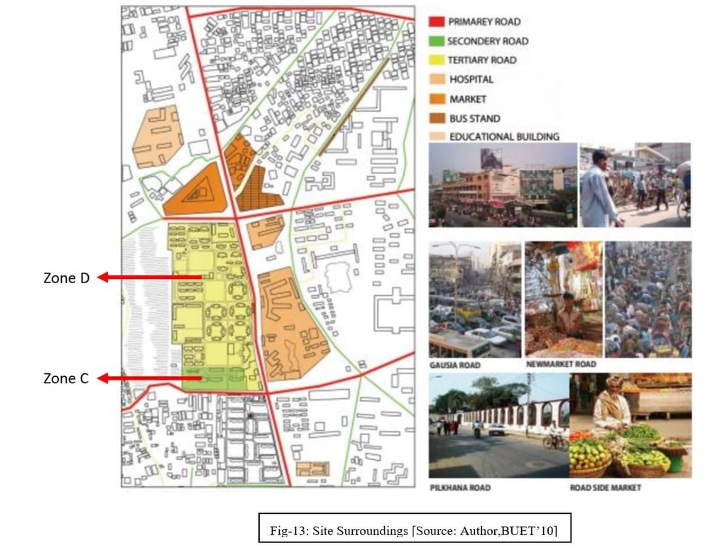
Road Network: The primary roads are Azimpur Road, New Market Road, and Pilkhana Road. These three Primary Roads surround Zone D. There is already an existing tertiary road network inside Zone D and C inherited from the past building pattern.

Site Accessibility: The site is accessible through the Pilkhana Road, New Market Road, and Azimpur Road. A minimum of three gateways is required. The traffic conditions and other aspects are illustrated below.
Community Space & Parking: There are some existing community spaces as several projects have been taken from the PWD to recreate urban spaces in the colony. Some project already has been completed. Azimpur Water Park, New Playground and Turf is one of them.

Land Use & Housing Pattern: The Azimpur Govt Colony has a mix of road patterns, representing the co-existence of different timelines and periods. Zone D & C has a kind of Quadrant Grid Iron Pattern.
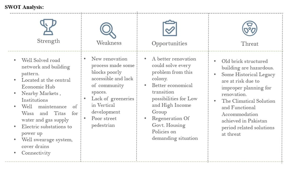
Site Justification: The site's 70-year-old morphological trend justifies its existence as a government housing site. Despite this, there are many other justifications for the renovation and revision process.
· Learning about a temporal transition, possibilities and solutions will help to design govt. Housing better.
Cluster analysis will help to sort out the highest possibilities for creating a public realm.
Different Types of building blocks create a demand for new government. Housing functionality solution.
Differentiating public and private housing will help us identify needs vs requirements.
The high need for government employee accommodation is supported by Azimpur govt housing.
Site Surroundings: The site is surrounded by three primary roads and New Market, Eden College and Home Economics College. The bus stand is located at northeast of the site and there are also some recreational and educational institutions, bazaars surrounding the site.
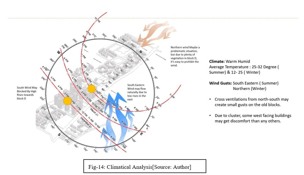
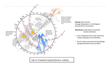
Climatic Analysis: In spite of being located in a crowded City Center, the Green Space Ratio, gives an advantage to the colony. The Temperature inside the colony ranges from 25-32 Degrees Centigrade in the summer and 17-24 in Winter. The New Landscape developed by PWD and the Architecture Department Created a Pleasant Community Place for the inhabitants. The Newly Developed Highrise can clearly contrasted to the green landscape of the colony which existed for 70 years.

Hydrological Essence & Waste Management: Water Supply and Sewerage Authorities are responsible for water, sewerage and drainage. The renovated pond is s good supply of water and Wasa worked for it to conserve the water and recycle the rain water that the reservoir reserved during the Monsoon.
There is no self-waste management system in this colony. The DCC is the responsible authority for waste collection. The newly developed high-rise colony also has no facilities for this.
Meet The Author


Related ARTICLES
Related PROJECTS
Revising The Renovation of Azimpur Govt. Housing , Dhaka - 1205
This project aims to provide a friendly framework for the future renovation or regeneration of these housing units in Bangladesh, taking into account the climatic and social factors that compel them to analyze the past, present, and future effects of this radical change in government housing, along with providing a structured policy for establishing government prototypes that enable government housing projects to be more sustainable and eliminate adverse effects.
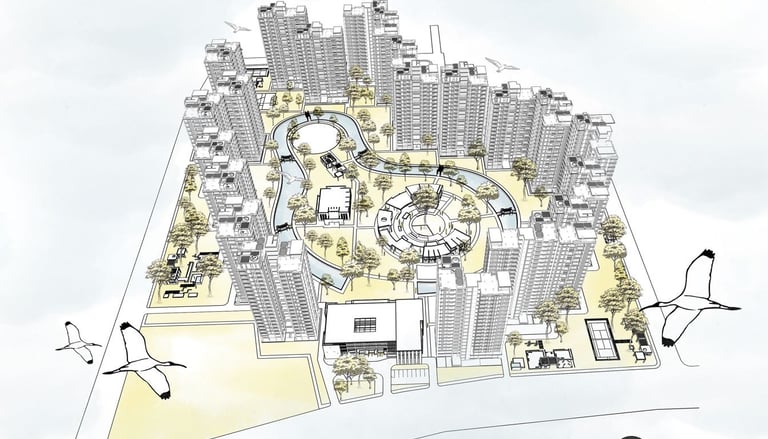
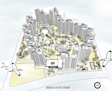
Image: Azimpur Govt. Housing Renovation Visual at Bird's Eye
Location: Dhaka-1205; Year: 2023